Ryan's Journal

"My life amounts to no more than one drop in a limitless ocean. Yet what is any ocean, but a multitude of drops?" — David Mitchell

Man Trip 2013

Posted from Paso Robles, California at 7:32 pm, December 27th, 2013

Audrey has dubbed the annual post-Christmas road-trip the “man-trip”, and this year’s adventure started off in much the same way as last year’s: a visit to the Cosumnes River Preserve followed by a sunrise trip to the Merced National Wildlife Refuge. The Pacific Flyway is busy this time of year, and it’s invigorating for the soul to stand on the edge of a wetland while tens of thousands of ducks, geese and cranes are calling out.

A big part of the fun of these trips is that I generally have no idea where I’m going to end up, and while the Ancient Bristlecone Pine Forest was considered, the closure of Tioga Pass sent me in the opposite direction, and it looks like I may be spending some time roaming the Carrizo Plain. The area became a national monument in 2001, but shockingly since my road atlas is out-of-date it’s a green dot within California that I’ve somehow never visited, an oversight that will hopefully be corrected tomorrow.

Great blue heron

Great blue heron at the Merced National Wildlife Refuge. He sat in the water thirty feet away so long as I stayed in my car, but the second the door opened he was gone.

Sandhill cranes at sunrise

Sandhill cranes at sunrise. The one on the left is bad at following.

Killdeer

Killdeer. After the heron experience I didn’t tempt fate by even thinking about exiting my vehicle.

August Recap Part 2

Posted from Culver City, California at 11:03 pm, August 28th, 2013

Following the wedding, the concert, and the working, August got a bit more nature-y.

Aaron had two bobcat sightings on Mt. Diablo recently, and since I didn’t want to be the only Holliday child not to see a bobcat in 2013 we did a couple of twilight hikes during the Bay Area visit. After some turkeys, bats and a few deer, the bobcat made an appearance on the trail ahead of us. You haven’t seen an annoyed cat until you interrupt a bobcat on his nightly rounds, but despite the attitude we were both pretty stoked at the find. The next night we took another hike in the same place, and while the bobcat stayed hidden the turkeys and bats were out again, and we also managed to spot a skunk and a tarantula. With Aaron having spotted the tarantula (two points) I negotiated for five points if I could get it to walk across my hand. The evening’s final score: Ryan 6, Aaron 3.

With a full weekend available for the drive home, the trip back to LA was via the scenic route. I’ve done a lot of road trips through the Sierras, but after scanning the map realized I’d never been through Sonora Pass and set off for the second-highest mountain pass in the Sierra Nevadas. It’s been far too long since this grown man slept in the back of a car, so after a late-afternoon bushwhack up a small peak the evening was spent sprawled out at high elevation in an automobile. The next morning the road led over the Sierras and to the ghost town of Bodie. During the gold rush days Bodie was a den of sin and hard-living, but today the sin has mostly gone elsewhere and the California park service maintains the town in a state of “arrested decay”. Another man might have walked through the deserted streets pretending to be a cowboy, but I’m 37 and clearly too mature for such shenanigans.

After leaving the ghosts the highway led to Mono Lake, and beyond that a pilgrimage was made to Galen Rowell’s Mountain Light photo gallery in Bishop; his photos are some of my favorites of all time. After that it was a straight shot south to LA, but Mother Nature intervened to make things interesting – a dust storm brought visibility down to almost nothing for a short time, and that was immediately followed by a lightning storm that struck a town next to the highway, setting something ablaze. Lightning has been rare during my time in California, so to not only see a huge storm but to also see it set a fire was pretty insane.

There are two weeks of vacation scheduled for September, so journal entries should be plentiful as Audrey and I head out on a couple of (brief) adventures, and provided UPS delivers on time they will be done with a new camera in hand.

Bristlecone Pine near Sonora Pass

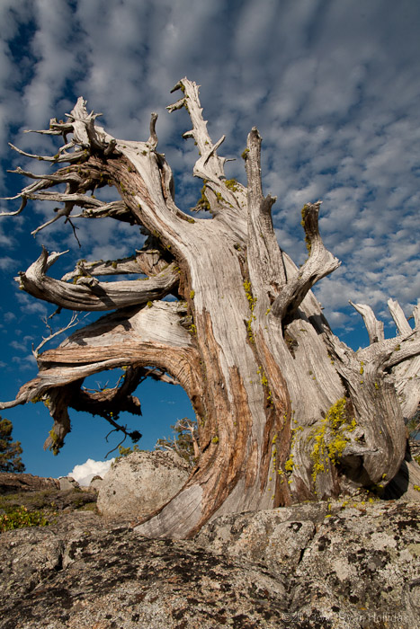
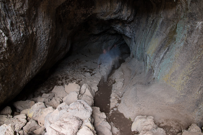
I decided to do some hiking in the high mountains, and pulled off the road by a smallish granite dome. My trailblazing was less-than-impressive, and I emerged three hours later with cut feet, torn pants, and this photo.

Bodie Ghost Town in the Eastern Sierra

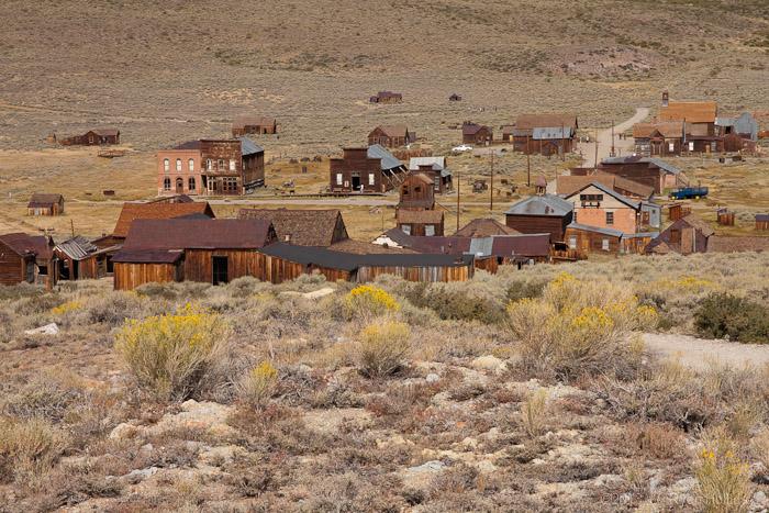
The ghost town of Bodie. The park guide notes that “by 1879 Bodie boasted a population of about 10,000 and was second to none for wickedness, badmen, and ‘the worst climate out of doors’“.

Mono Lake Tufa Towers

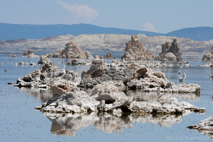
The tufa towers of Mono Lake. These should be underwater, but diversions for the city of LA have dropped the level of Mono Lake by more than thirty feet.

Too Many Words

Posted from Boise, Idaho at 7:35 pm, February 18th, 2013

The recent journal entries have lacked in pretty pictures, so before boring my twos of readers with yet another verbose saga about the life of Holliday, here are a couple of pretty pictures from the December roadtrip. The first was taken early in the morning fog at Merced National Wildlife Refuge prior to a massive breakfast, while the second is from an afternoon in Death Valley.

Foggy Landscape in Merced NWR

Foggy Landscape in Merced NWR.

Foggy Landscape in Merced NWR

Zabriskie Point in Death Valley National Park.

The Valley of Death, Part II

Posted from Lancaster, California at 8:53 pm, December 30th, 2012

I hiked a couple of miles out into the Badwater salt flats early this morning, sat down in the snow-white crystals of a dried up salt pool, and the desolation was glorious.

After a good night’s rest the morning featured some sunrise photography, a hike through the Badwater salt flats, and a delicious burger for a hungry boy. Post-burger the itinerary included a visit to the yellow formations of Zabriskie Point, and a drive up to Dante’s View. I thought I’d been to this overlook before, but I don’t remember it, and it’s a memorable spot with a five thousand foot sheer drop down to the valley floor and a ridiculously great view of the awesome geology of the surrounding landscape – since that’s three superlatives, odds are that my memory is faulty and this is a spot that has not been on a past trip itinerary.

After leaving Dante’s View the trail led towards home via the eastern Sierra, with a brief stop to enjoy the Milky Way, and the current stop to try to get a journal entry written before it gets too late (aka 9PM) and my brain starts getting mushier than normal. Tonight will be spent in a real bed as this end-of-year trip sadly comes to its end.

Badwater Basin Sunrise

Badwater Basin sunrise. The color on the mountains was also impressive, although you wouldn’t know it from the pictures I took.

Badwater Basin Salt Flats

Badwater Basin salt flats. See all the people? No? Glorious!

The Valley of Death

Posted from Above Badwater Basin, Death Valley National Park, California at 7:08 pm, December 29th, 2012

Some thoughts from today:

  • There is all kinds of cool stuff happening in the desert town of Mojave. Scaled Composites (the first private company to put a man in space) is there, along with Virgin Galactic and all manner of other cutting edge aerospace companies.
  • Off roading is apparently a much bigger deal than I realized. While roaming dirt roads in the desert I passed hundreds of RVs organized into camps of 5-20 vehicles, each camp home to dozens of ATVs and dirt bikes. One of the RVs in every camp was always flying a giant flag, and I’m gonna go out on a limb and say that these same folks show up in force for Nascar.
  • The craggy, primordial landscapes in the deserts of the Eastern Sierra are the types that require the internal narrator to assume a deep voice and say things like “and thus did God create the EARTH”, with backing music from a booming timpani drum. Driving through this area, it really does feel like this is how the Earth looked a couple billion years ago.
  • Despite many past visits to Death Valley the Wildrose portion of the park is somewhere I’d never been before today. That part of the park is at a higher elevation and featured a bit of snow, along with a landscape through tiny canyons and vistas that kept making me think how crazy it was that they even built a road here. This area is now officially Ryan approved.
  • I debated spending the night car camping in the campground at Furnace Creek, but instead of spending the evening wedged between RVs I decided to haul the Suby a few miles up a “road” (*cough* rocky gully *cough*) and am camped for the evening with a view that includes the entire Badwater Basin and has no neighbors. Provided I don’t wake up in the morning with one or more flat tires this appears to be a far better sleeping option.

A Day at the Refuge

Posted from near Buttonwillow, California at 7:39 pm, December 28th, 2012

In the 1800s there was wetland from Sacramento to Bakersfield, and a person could travel the entire route by boat. Today ninety-five percent of that has been converted to farmland or cities, so one can only imagine how insanely awesome the wildlife must once have been.

Wakeup was at 6AM to catch sunrise at the Merced NWR and to hopefully see the cranes before they dispersed for the day. It was ridiculously foggy, but the calls of several hundred cranes helped with locating the birds and I managed to grab a few shots as they departed to their favorite breakfast spots. Unfortunately the elusive “money shot” was not to be had today, so a crane photo remains on the bucket list.

The entire day was spent at the refuge, with a brief intermission to eat a massive biscuit and take a shower. Hawks, herons, and a few thousand snow geese were among the day’s other sights – if what I saw represents five percent of the historic abundance, the Central Valley must have been a wonder in its wildlife prime. Tonight will most likely again be spent sleeping in the glorious confines of the Subaru, with tomorrow’s plan (subject to change) being to meander along a route to Death Valley that I’ve never tried before.

Sandhill cranes at sunrise

A flock of about two hundred cranes dispersed in a matter of minutes when the sun came up, making for a frantic and fun photo shoot.

White-fronted geese and the full moon

A shot from yesterday of white-fronted geese flying past the full moon. I thought this was a neat shot although perhaps a bit too odd for the journal, but Audrey gave her approval.

Several Thousand Geese-a-Flying

Posted from Merced, California at 10:06 pm, December 27th, 2012

After a bird-themed Christmas, waffles, a game involving trains (a recurring activity this holiday season, apparently), and hiking in the mud with Aaron I took leave of Ma & Pa’s house and returned to the road. Today’s stop was at the Cosumnes River Preserve, home to (literally) tens of thousands of geese and numerous other feathered critters. Having flocks of thousands of geese and the occasional sandhill crane passing overhead as the sun set was not a bad way to finish the day.

Several thousand white-fronted geese take to the skies as the sun sets. Turn up the volume for maximum enjoyment.

Chasing Cranes

Posted from Concord, California at 10:46 pm, December 24th, 2012

Last night was spent sleeping in the back of the car on the side of the road. It felt good to be a vagabond again.

Today’s adventure was a tour of several wildlife refuges to scout possible locations for the sandhill crane picture that has eluded me for so long. While the birds were again uncooperative, there’s hope. The morning’s first visit was to Merced National Wildlife Refuge, home to a ridiculous number of cranes and the new number one contender on the crane photography list. Arrival was too late for good light, but this is a place that will be re-visited.

The second planned stop was the San Luis National Wildlife Refuge, but Apple’s new map tool calculated a route that went from sketchy country road to potholed mess to muddy quagmire. I was skidding all over the place, tearing up clay, doing my best to avoid sliding into the irrigation ditch next to the road without reducing speed to the point where I’d get trapped in the muck. When eventually I found a place wide enough to turn around I was absolutely positive that the car would get stuck, but a Christmas miracle occurred and the Suby dug its way out and I escaped without a call to AAA. After this mini adventure there were disconcerting squealing noises coming from the front of the vehicle, so I headed to the nearest town where it took a full twelve minutes of power washing to get all of the clay/mud out of the wheel wells and axles.

After finding a new route that followed actual roads I arrived at San Luis NWR, which was scenic, as was the day’s final stop at the Isenberg Crane Reserve. However, Merced NWR was clearly the winner and a spot that will see another visit on the post-Christmas trip. In the interim the plan calls for spending a couple of days at Ma & Pa’s for the annual family Christmas, feasting, and misadventures with my brother.

Red-tailed hawk at Merced National Wildlife Refuge

Red-tailed hawk at Merced National Wildlife Refuge. My copy of the Sibley guide is at home, so I’m basing this identification on the fact that I generally assume all big hawks are red-tails.

Refunds

Posted from Culver City, California at 7:25 pm, December 31st, 2011

While the bed was a good thing last night, air quality in Kern County is ridiculously poor – dust, smog and huge cattle feedlots make for a stinky, hazy landscape, and whether due to the air, a bad meal, or flu, I got up at 5AM this morning to refund my dinner – twice. Return to the wildlife refuge was delayed a bit as a result, but once there the cranes were found in abundance. Sadly the birds were ridiculously wary, so the sandhill crane remains a photograph on the “most wanted” list.

The trip came to an end by midday with a return to Culver City. A week of time off from work remains, with the plan being to spend time on side projects and visit some local attractions with Audrey. Additionally, I need to figure out the score card on my 2011 predictions (it doesn’t look good), and come up with some highly questionable picks for 2012.

Who Knew?

Posted from Delano, California at 8:50 pm, December 30th, 2011

Ryan is in a hotel tonight. For the first time in four nights a bed, a shower, and a change of clothes are coming, and happiness and joy shall follow.

Last night was again spent car camping, allowing the trip to resume from Yosemite Valley with an early morning view of the valley from Tunnel View as the payoff. A trip to the Mariposa giant sequoia grove followed – the trees are beyond impressive, and after finding a quiet trail to escape from the surprisingly large and loud crowds the trees worked their magic on this normally office-bound traveler, helping to restore some order to the universe.

After leaving the park I scanned the map for green dots along SR-99, and stumbled on the Pixley National Wildlife Refuge. A late day arrival at the refuge allowed for a short hike, but aside from a few hawks and waterbirds the animals seemed to be in hiding. That is, they were hiding until sunset, at which point all hell suddenly broke loose. Hundreds upon hundreds of sandhill cranes started calling out while flying overhead, a pack of coyotes began howling in an adjacent field, and I accidentally spooked an owl who flew out of a tree next to me and began hunting the fields nearby. What had been a moderately interesting stop suddenly morphed into a reason to spend the night in Kern County, and the plan is to return, camera in hand, to see if the wildlife chaos continues at dawn.

El Capitan from Tunnel View, Yosemite National Park

El Capitan from Tunnel View. If this rock formation doesn’t look impressive to you, look closely at the top – those tiny green things are full-grown ponderosa pine trees.

Sandhill Cranes, Pixley National Wildlife Refuge

Sandhill cranes at sunset. Multiply this flock 100x, add in the amazing sound of the birds calling, and put a better photographer behind the camera, and you’ll have some sense of what the sky was like once the sun went down.

Tioga Road

Posted from Yosemite Valley, Yosemite National Park, California at 7:39 pm, December 29th, 2011

Last night’s bed time was 8:00 PM – writing this entry tonight at 7:35 is clearly pushing my current limits. The adventure for the day began just before six and led through Yosemite’s high country along Tioga Road, a path that closes with the first snow each winter but remains open this year due to one of the driest Decembers on record. God was obviously feeling manly when he created this part of the world, and it was a fun outing amongst the rocky crags, with plenty of quiet time available to ensure that things were right with the world.

Tioga road ends at Highway 395 and Mono Lake, and while the latest version of the plan called for spending the remainder of the trip going south along the Eastern Sierra, a sudden change of mind resulted in a brief visit to the lake and then a return through Yosemite. A hike up Pothole Dome near Tuolumne Meadows finished off the afternoon, and the evening will again be spent camping in Yosemite Valley with tomorrow’s plans somewhat uncertain.

High Sierra, Yosemite National Park

View from Olmstead Point. There is a lake barely visible above the trees that was frozen solid and covered in ice skaters.

Tuolumne Meadows, Yosemite National Park

View of Tuolumne Meadows from Pothole Dome. Bob Ross would not have referred to this as a “happy cloud”.

Day Two

Posted from Yosemite Valley, Yosemite National Park, California at 6:21 pm, December 28th, 2011

I slept in a rest area next to I-5 last night because that’s obviously what well-adjusted, successful, 36 year old IT professionals do. Pulling into the parking spot two dozen pairs of eyes reflected back in the headlights – I’ve never seen so many rabbits in such a small area, although later in the evening a screaming kid and two dogs put an end to the Watership Down reunion. Wake up this morning at six-ish allowed plenty of time to amble along towards Yosemite, and the day was spent roaming some of the non-knee-breaking trails in Yosemite Valley. Past trips to the park have intentionally avoided the really touristy spots, but given the knee issues and the smaller crowds it seemed like a good time to finally visit places like Lower Yosemite Falls and the Ahwanhee Hotel. Tonight will be spent car camping in the park’s main campground, and tomorrow it’s off at sunrise for a day-trip through the high country.

Half Dome, Yosemite National Park

Half Dome. If my knee was in better shape then I would be in the photo, at the top, standing near the edge, looking exhausted.

Half Dome, Yosemite National Park

At sunset Half Dome turned a brilliant red color. Sadly the bottom two-thirds remained in shadow, so in a burst of creative genius I only photographed the top.

Bodega

Posted from Livermore, California at 7:56 pm, December 27th, 2011

Day one of what Audrey has dubbed the “man trip” – luckily the girl recognizes that sometimes the boy needs time alone to, as she calls it, “sleep in the dirt”.

After waking up at 6:30 in the Holliday family compound the Subaru and I set off in soup-like fog towards Bodega Bay. A detour at the San Pablo Bay National Wildlife Refuge resulted in some quality bird time, including an egret who was impressively unafraid. The fog finally broke around 10AM, and Bodega Bay yielded a massive number of seabirds, hawks, vultures, sea lions, and two grey whales, although (surprisingly) not a single photo. For future reference: December/January and March/April are whale migration times, and unless today was unusual they travel extremely close to shore. After some hiking and a ginormous seafood lunch the few remaining daylight hours were spent heading south through Point Reyes and along Highway One, aka the most scenic road in the USA.

The current plan is to go to Yosemite tomorrow, but given past precedent a betting man would not be unwise to take odds on that plan being derailed by an unforeseen side-trip. However, with Tioga Pass apparently still snow free the chance to see Yosemite’s high country in late December seems like an opportunity not to be missed.

Great egret, San Pablo Bay NWR

Great egret, San Pablo Bay NWR. This bird was surprisingly unafraid, although perhaps word has gotten out about my less-than-stellar hunting abilities.

Dropping a Ball

Posted from Culver City, California at 8:20 pm, December 31st, 2008

Day three of the post-Christmas adventure started with a hike up to the Mount Whitney trailhead through snow, ice, and some impressive scenery. After spending four hours adding to yesterday’s blister count I returned to the Suby and took off south with no real destination in mind. California is one of those unique places where a random highway can lead to truly bizarre sights, and while today’s find can’t compare to the weirdness that is the Salton Sea, finding myself on a road between a Naval Weapons station and a massive RV/ATV gathering in the middle of the desert was unusual enough to make the day a success.

Smiling’s My Favorite

Posted from Near Big Pine, Eastern Sierra, California at 5:30 pm, December 30th, 2008

Christmas this year was again spent at Ma & Pa’s house in the Bay Area. Aaron was given the gift of Cavs tickets and an Anderson Varejao wig, the Skipper got a cookbook for curry (he cooks now), and Ma got enough pedicure gift certificates to keep her toes pretty for months. In a surprise move, rather than the usual gifts of sweaters and bizarre neck massagers mom also put together a really awesome album with copies of the family Christmas cards and letters going back about twenty years; Aaron and I were expecting the worst when she told us to “close our eyes”, so this gift was a pleasant surprise.

This year’s holiday miracle came in the form of a visit from Roto-Rooter after Mr. Hanky the Christmas Poo took up residence in the downstairs bathrooms. Combining blocked toilets with the holidays brings out the best in everyone, and despite Sally’s initial dismay and Aaron’s dry-heaving it ended up being a fairly amusing (if expensive) event.

Tonight I’m camped out in a closed forest service campground in the Eastern Sierra near the base of Mount Whitney. After driving through gold country and up to Tahoe yesterday I spent the night in Carson City before heading south today. Hiking and photography at Mono Lake went well, although the silver dollar-sized blisters on my insteps indicate that the afternoon’s attempt at cross-country skiing was less successful. The interesting fact of the day comes from Mono Lake, which apparently lost forty feet in depth (and a signficant amount of surface area) due to diversion of streams by the city of Los Angeles starting in 1941. As of 1994 a lawsuit requires LA to restore twenty of the lost forty feet to the lake level to provide improved habitat for the two million birds that visit the lake each year, although at present the lake has risen only about eleven feet from its low point. Along with the restoration of the Lower Owens River, returning Mono Lake to a healthier state could have a huge impact on the wildlife that migrates through the Eastern Sierra each year, thus making me the slightest bit more optimistic that people may actually make the world a bit better during the remaining decades of my lifetime.

Sierra Nevada Winter Landscape

Sierra Nevada Winter Landscape.